I will preface that this post is part 2 of my previous article titled “What If …? “
Did he or didn’t he? That’s the question. Did William Longmire draw and/or write anything on the so-called 1728 “Plan of the Town of Fredericksburg” survey map below? And what do we know about this map and how might a fellow with such an ignominious start in Virginia be involved?
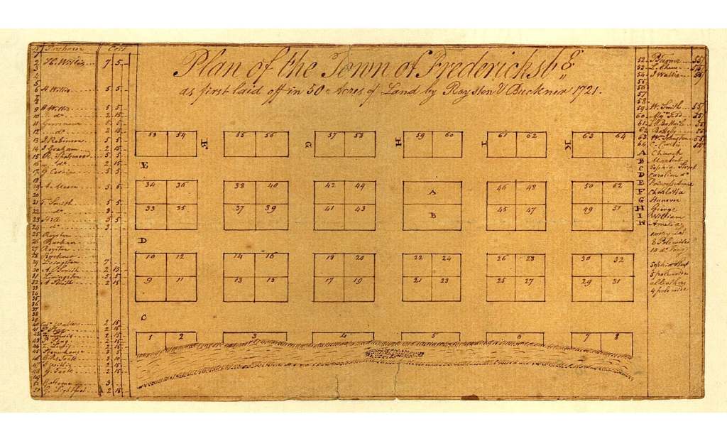
The creation of the town map of Fredericksburg above is usually considered as dating to 1728. It is sometimes credited, erroneously, to John Warner who is known to have laid out the towns of Fredericksburg and Falmouth in 1728. However, the original map and/or survey by him is known to be lost. And there is the curious issue of lots sold being listed on the margins of the map well into 1730. And though John Warner did most of his work for Lord Fairfax it is of interest that he was called upon to also lay out and draw a survey for a town which was a beachhead of sorts for the Colony of Virginia. A Crown interest, if you will. So, it comes as no surprise that another surveyor laid out and mapped, on order of the Town Trusties, an illustrious lot (pun intended), the town in August of 1728. And if you glance back up you will note that neither he nor Warner are noted/credited on this particular map. It’s a hell of a thing. Methinks it likely a third copy, solely attributing it to the original town surveyors/planners, Royster and Buckner in 1721 as stated in the map header. Let’s move along as the plot thickens … you saw that, right?
Well, I did let slip in a recent post that some felonious aspect to this debacle was afoot. Yep, none other than the “other” surveyor was a fellow by name of George Hume from Scotland. And not only do the history books mention that he evaded a probable death sentence after conviction for his Jacobite activities but entered the Colony of Virginia as an indentured slave. However, a technicality might suggest that he was “exchanged” previous to arrival. Nonetheless he and the hat thief shared a common denominator:) And that is another avenue of interest as these two gentlemen could not be farther apart in some sense and possibly closer than others. Digressing as usual I will pass along the mere fact that he was not only imprisoned but the family land and title confiscated. Tough luck, kid. But guess what? In a feat of irony he not only arrived in Virginia in 1721, but was summarily sent to … drum roll … Williamsburg College. By none other than Gov Spotswood. He was a nephew of the Governor. Like, way. Anyways, his timely and well suggested vocation of surveyor by his uncle, and after already having a mathematics background from earlier schooling in Scotland, he was a natural to become the great surveyor that history affords. Quick tidbit: look up Knights of the Golden Horseshoe or George’s father and/or grandfather and you see that he and our friend from London ran in the same circles here, but their lives before crossing the ocean were vastly different. And yet, these two fellows seem to have crossed paths one way or another. George Hume was also one of Lord Fairfax’s main surveyors. Hmmm …
Well, as usual, I left a thing or two out. Sometimes you just need to start a new paragraph, get your bearings … you saw that. I think it’s just way cool that Wm Longmire was not only working with John Warner, the gentleman whose surveying exploits for Lord Fairfax and his map of Virginia is of legendary status in the cartography world … but the real possibility that he also worked with, in some capacity, George Hume, who is legendary for teaching young George Washington the mystery and art of surveying when he became of age. One way or another it is historically noted that George Washington used to study these early surveys and practice surveying before age 16 with those same drawings. Drawings which George referred to, partially, in his legacy property and farming documents* found in the Library of Congress. Historical drawings some of which were annotated and/or partially executed by Wm Longmire. That’s worth a gold star on the fridge.
* Washington Family Papers. note – Rev Charles Green Deed involving Fairfax and maybe the Belvoir land written as a grantee document by Wm Longmire.
I would be remiss for not mentioning another aspect or two of this case which might add a twistory pinch. Did anybody happen to notice the beautiful penmanship of the Fredericksburg map header? Might that look familiar? Hmmm … what if
And that leads into another angle of inquiry… if you saw that. What if Wm Longmire actually worked on maps BEFORE he even met up with Lord Fairfax? And if he did what are the ramifications? Total cartographic and Virginia historical chaos of sorts. It may call into question, and answer to, certain narratives. If I am to bring this full circle, and end up at the beginning, a term apropos on a survey or two William himself wrote, what other supporting evidence is there? Funny you should ask.
Like any classic episode of Colombo or typical crime drama it seems the suspect makes an appearance early on but with little fanfare. Somebody that you look back to in retrospect and say yeah, right. That guy. Well, I got a guy. And my elaborative construct above might dovetail in too neatly or might make all the sense in the world. Some might say I am going off on a tangent … you did not see that. So, how do you link this all together with some cognitive persuasion, Longmire? Did you see that?
“Sic juvat transcendere montes”
And with that I check my moral compass and feel satisfied that the next installment of the hat thief’s adventures will point to the most likely suspect in the nexus of a possible mystery unfolding … Be sure to bring a good pair of glasses or digital magnifying savvy. We’re gonna look at another survey map. Dated and signed by John Warner right about the time he did Augustine’s survey. Might be fun:)
Categories: Uncategorized

